There have been rather a few earthquakes centred near Kaikoura recently.
NZST: Wed, Sep 24 2008 2:59 pm
Magnitude: 3.6
Depth: 20 km
Details: 50 km north-east of Kaikoura
NZST: Thu, Sep 25 2008 10:40 am
Magnitude: 5.1
Depth: 20 km
Details: 40 km north-east of Kaikoura
NZST: Thu, Sep 25 2008 3:30 pm
Magnitude: 2.9
Depth: 20 km
Details: 20 km north-east of Kaikoura
NZST: Thu, Sep 25 2008 3:57 pm
Magnitude: 4.6
Depth: 20 km
Details: 20 km east of Kaikoura
NZST: Fri, Sep 26 2008 7:23 pm
Magnitude: 5.2
Depth: 25 km
Details: 20 km north-east of Kaikoura
Reference Number: 2974715
NZST: Fri, Sep 26 2008 9:39 pm
Magnitude: 3.8
Depth: 30 km
Details: 20 km east of Kaikoura
And a quick look at the Kahutara quake drum currently shows that things are still going sproing every now and then.
I think I actually heard the house creak for the two bigger ones on Friday evening, but the wind was blowing pretty hard at the time, so I didn't think earthquake.
Hopefully it's just easing off some pressure, preventing something bigger from happening...
Monday, September 29, 2008
Thursday, September 25, 2008
Another quake
I missed another one...
NZ Standard Time: Thursday, 25 September 2008 at 10:40 am
Latitude, Longitude: 42.34°S, 173.91°E
Location: 20 km east of Kaikoura
Focal depth: 50 km
Richter magnitude: 5.0
Web page: http://www.geonet.org.nz/earthquake/quakes/2974058g.html
Widely felt across central New Zealand, from Canterbury to the Wellington region
EDIT:
Didn't feel the aftershock either!
NZ Standard Time: Thursday, 25 September 2008 at 3:57 pm
Latitude, Longitude: 42.32°S, 173.95°E
Location: 20 km east of Kaikoura
Focal depth: 20 km
Richter magnitude: 4.6
Web page: http://www.geonet.org.nz/earthquake/quakes/2974157g.html
Wednesday, September 24, 2008
Monsoon season
It's kind of saddening to see that when a bunch of westerners get killed in any disaster, it's generally quite prominant in the news, but when 200 people in India are killed by floods, 1500 in India and Nepal since the start of monsoon season in June, it doesn't even make it into the Dominion Post! 57,000 people evacuated in one area, 300,000 in another - that's really not insignificant!
http://www.stuff.co.nz/4703095a12.html
http://www.stuff.co.nz/4703095a12.html
Monday, September 22, 2008
A light zephyr...
Might get a tad breezy from tomorrow afternoon until early Wednesday morning. We've just received a severe weather warning from the MetService, forecasting winds around 7okm/h, gusting to 120km in exposed places. Why does it always happen for rubbish day?! There's going to be trash all down my street if people put the garbage and recycling out tonight...
You may want to bring in anything which might get blown away, and if it's rubbish day tomorrow, please hold off on putting out the trash until the morning, so it doesn't have all night to be tossed around by the wind.
You may want to bring in anything which might get blown away, and if it's rubbish day tomorrow, please hold off on putting out the trash until the morning, so it doesn't have all night to be tossed around by the wind.
Wednesday, September 17, 2008
What's Taupo up to?
Seems to be a bit of a quake swarm near Taupo at the moment. I wonder what's up with that?
 Image from www.geonet.org.nz
Monday, September 15, 2008
Another local quake
If you woke up slightly before your 7am alarm this morning, it may have been due to a small earthquake at 6:56 am. It measured 3.3 on the Richter Scale, and was centred 10km north-east of Porirua, and 30km down. Not particularly big, but apparently it was enough to send some people scurrying for the doorway. I'm entirely certain that I slept through it. The cat jumping on the bed produces a bigger shake than that.
http://www.geonet.org.nz/earthquake/quakes/2969006g.html
http://www.geonet.org.nz/earthquake/quakes/2969006g.html
Thursday, September 11, 2008
Still here...
Various people have been worried that the Big Bang experiment in the Large Hadron Collider on the border of Switzerland and France will cause the creation of a black hole, bringing about the end of us all.
Well, they've turned it on... http://www.stuff.co.nz/4688894a12.html
There isn't really much you can do to prepare for the implosion of the planet, but if you'd like to keep an eye on whether they've killed us all, check: http://hasthelargehadroncolliderdestroyedtheworldyet.com/
Well, they've turned it on... http://www.stuff.co.nz/4688894a12.html
There isn't really much you can do to prepare for the implosion of the planet, but if you'd like to keep an eye on whether they've killed us all, check: http://hasthelargehadroncolliderdestroyedtheworldyet.com/
We're not in Kansas anymore, Toto...
Nope, Dorothy's still in New Plymouth. A small tornado went through New Plymouth this morning. Police said the tornado hit suburban Bell Block shortly after midnight. There was some property damage, including roofs blown off and power lines down, but no reports of any injuries, or anyone ending up in Oz.
Tuesday, September 9, 2008
Hurricane season
Unfortunately, I'm not talking about the rugby team. I think that Mother Nature is the winner on the day for this game...
The 2008 Atlantic Hurricane Season officially kicked off on June 1, though Tropical Storm Arthur decided to beat the rush and get in early by forming on May 30. The season will continue until 30 November 2008. Currently, the season has produced 10 storms, 5 of which made it to hurricane status, 3 of which have rated higher than 3 on the Saffir-Simpson Hurricane Scale.
Hurricane Hanna has been responsible for over 500 deaths on Haiti, bringing the season's current death toll to almost 800.
Wikipedia has a very good up-to-date article on the current season - http://en.wikipedia.org/wiki/2008_Atlantic_hurricane_season
Missed it again
Is it a bad thing that I'm disappointed when I don't feel an earthquake? Missed another one on Saturday - I think I was doing some gardening when this one hit at 2.58pm, just 10km north of Upper Hutt.
http://www.geonet.org.nz/earthquake/quakes/2964546g.html
http://www.geonet.org.nz/earthquake/quakes/2964546g.html
Readynet comes to Porirua
Readynet has come to Porirua!


http://www.readynetinfo.co.nz/Site/default.aspx
Readynet is a tool which enhances and develops the way that individuals and organisations in the community both think and act with regards to emergency preparedness and response. It's a simple web-based application which asks you to populate and maintain a database with the information that will help both you and the emergency services in the event of an emergency. It also enables emergency managers to provide immediate, 24/7 emergency communication to principals via pre-programmed group-send text messages and email.
We all know that we should have a comprehensive plan for what to do in the event of an emergency, but it is often very difficult to know where to start, or know if you are missing some information which could be vital. Readynet solves this problem with simple online forms to fill in, and a benchmarking system that lets you know when you have provided enough information. The information collected is automatically formatted to create a comprehensive and nationally consistent Emergency Action Plan for your school/facility/business/community group's use, as well as the emergency services and the council's Emergency Management Office. A reminder system is in place to help you keep the information up to date.
All the information is stored in a secure and encrypted website, similar to internet banking, which you can access and update at any time. The council's Emergency Management Office will regularly download and store an electronic version of your plan on laptops for use in the event of a mains power failure or loss of internet capability.
Porirua City Council has funded the implementation of Readynet in Porirua, so it is available to schools, universities, rest homes, motels, businesses, Neighbourhood Support Groups, and special interest groups in Porirua, absolutely free! No joining, license or subscription fees.
Readynet has been in use in the Hutt Valley since 2006, and has already been used to great effect in actual emergencies.
To register with Readynet, please email emergencymanagement@pcc.govt.nz, or call Porirua City Council 237-5089.
Wednesday, September 3, 2008
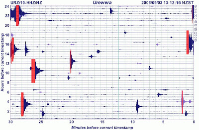
Matata going off again
Matata, in the Bay of Plenty, gets a lot of earthquakes - lots of little ones in swarms.
If I see a quake notification hit my inbox, and it's from the Bay of Plenty, I can pretty well guarantee it's from near Matata.
Here's a look at the latest reading from the nearest seismograph. Thanks to GeoNet.
If I see a quake notification hit my inbox, and it's from the Bay of Plenty, I can pretty well guarantee it's from near Matata.
Here's a look at the latest reading from the nearest seismograph. Thanks to GeoNet.

Unnatural events
Not all emergency events are caused by Mother Nature. Sometimes we're the ones who cause the incident - just like today, where a chemical leak in Christchurch has caused the evacuation of a processing plant, and several city blocks surrounding the site. Nine people have been taken to hospital so far, after being overcome by fumes, and the police & fire service have set up decontamination showers for people leaving the area. I've seen decontamination showers in action, they aren't a lot of fun for the person being scrubbed down - though certainly better than whatever the contamination was going to do to you.
http://www.stuff.co.nz/4679493a11.html
And occassionally we do something bad to Mother Nature - there's the Sidoarjo mud eruption in Java, Indonesia, which has continued unabated for almost two years, flooding an area of 7 km2 and displacing more than 25,000 people. There is some debate as to the cause of the eruption, but scientists now blame a well drilling blowout, rather than an earlier earthquake. Oops! Bit worse than hitting the water or gas main with your digger....
http://geology.geoscienceworld.org/cgi/content/abstract/36/8/639
http://en.wikipedia.org/wiki/Sidoarjo_mud_flow
Monday, September 1, 2008
More Kawakawa Bay properties at risk from landslip
A large landslip in Kawakawa Bay, in the Manukau District, near Auckland, has caused 6 properties to be declared to be unsafe, forcing the residents to move out. The road is also closed, and could stay that way for up to a month. Because of the inconvenience to residents, the council will put on a free ferry between Kawakawa Bay and Pine Harbour marina, as well as a limited bus service to Papakura and Thames. Other contingency plans are also being put in place. Students who normally go to school in Clevedon will use a room at Orere School and be taught by their usual teacher. Work is also being done to make sure electricity and phones won’t be cut off if a landslip happens. The council is also looking at temporary alternative routes around the landslip.
http://www.manukau.govt.nz/default.aspx?id=9651
http://www.zoomin.co.nz/map/nz/manukau/kawakawa+bay/ - a map so you have some idea of where it is.
Imagine not being able to drive down the road for a month, and having to catch a ferry to get out of town. That's what it could be like for us, if a big quake took out the main roads in. Even though we're a good sized city, it's pretty easy for us to be cut off.
Missed another one!
Rather busy day today! A quake measuring 5.8 has struck 10km south-east of Turangi, near Lake Taupo. Apparently it was felt as far away as Wellington, but I didn't feel a thing! How disappointing! I went to check the seismographs on GeoNet, but they seem to be having a few problems at the moment, and haven't updated in a few days. But if you felt the earth move at 1.21pm, then please fill in a felt quake report
At least we're not on the West Coast!
Can you imagine getting half a metre of rain dumped on you in just three days? Well, that's what the MetService is saying that the Westland ranges and Southern Alps can expect this week. 500mm!
The wild weather is the result of a record-breaking, 1040HP high-pressure system, which the MetService's Bob McDavitt said is a first for New Zealand. "It's breaking all records, we've never seen a high this big over the country before. We haven't got any explanation as to why this high-pressure is so high."
Strong winds are also expected to batter the South Island, with gusts up to 140kmh predicted for inland and exposed parts of Southland, Otago, and Canterbury this afternoon, easing later tonight.
You thought our rain was bad?
Spare a thought for the poor people of South Asia, where hundreds of thousands of people are marooned in remote villages by flooding caused by the monsoon rains.
Floods have killed more than 1000 people in South Asia since the monsoon began in June, mainly in India's northern state of Uttar Pradesh, where 785 people died, and deaths were also reported in Nepal and Bangladesh. At least 3 million people have been displaced and those figures could rise as heavy rain continued, officials said.
The latest flooding occurred after the Kosi river burst a dam in neighbouring Nepal earlier this month and changed its course, swamp hundreds of villages in Bihar and destroy over 100,000 hectares of farmlands. More than 350,000 people have been evacuated over the past 11 days, officials said, admitting they did not have enough boats or resources to step up relief operations. Cases of diarrhoea were beginning to be reported from many relief camps in the state, Unicef said.
http://www.stuff.co.nz/4675899a12.html
Hurricane Gustav
The mayor of New Orleans has ordered the evacuation of the city, in the face of Hurricane Gustav, a category four hurricane, the second-highest on the five-stage Saffir-Simpson scale, labelled "the mother of all storms". The hurricane had weakened to category three over Cuba, where it killed at least 86 people, but it still looks as though it is more powerful and more destructive than Hurricane Katrina which devastated the area in August 2005.
Just one day after the third anniversary of Hurricane Katrina, many had already decided to leave their homes, with the government providing buses and trains for those who can't leave without assistance.
The city's West Bank was largely spared by Katrina, but could see "significant flooding" because its 3-metre levees are no match for Gustav's storm surge, which could top 5 metres.
Katrina's massive storm surge broke through protective levees on August 29, 2005, and flooded 80 percent of the city. It killed about 1500 people along the US Gulf Coast and caused US$80 billion in damages, making it the costliest US natural disaster.
There was bumper-to-bumper traffic on highways leading out of the city on Saturday, and six low-lying parishes - the Louisiana equivalent of US counties - issued evacuation orders.
All major Louisiana interstates will allow only one-way traffic away from the coast starting at 4am (9pm NZT) on Sunday. The last flight out of the New Orleans airport is scheduled to depart at 6pm (11am Monday NZT) on Sunday.
In all, 11.5 million people are in the path of Gustav, according to the US Census Bureau.
http://www.stuff.co.nz/4675601a12.html - New Orleans mayor orders evacuation
http://www.stuff.co.nz/4675927a12.html - Thousands flee New Orleans
http://www.stuff.co.nz/4676485a12.html - Possible scenarios for Hurricane Gustav
http://www.stuff.co.nz/4676503a12.html - Cuba tallies Gustav's economic damage
Just goes to show...
The Chinese province of Sichuan has been hit by another earthquake - measuring somewhere between 5.7 and 6.1 (reports vary), at about 7.30pm NZ time. It killed 28 people, injured 250, damaged or destroyed nearly 100,000 homes, and affected at least 600,000 residents. It was followed 24 hours later aby a 5.6 aftershock, from which there were no immediate reports of damage. Over 600 schools were damaged, and heavy rain and difficult terrain were hindering rescue efforts.
Compare this to New Zealand. Hastings was hit by a quake that measured 5.9 on the Richter Scale, just last Tuesday. It moved some furniture around, and knocked a lot of things off shelves, but really didn't cause much structural or significant damage. Even the Gisborne quake, measuring 6.8, didn't cause that much damage - all thanks to New Zealand building standards. It all goes to show that building standards make a difference. We have them for a reason, so no cutting corners!
Compare this to New Zealand. Hastings was hit by a quake that measured 5.9 on the Richter Scale, just last Tuesday. It moved some furniture around, and knocked a lot of things off shelves, but really didn't cause much structural or significant damage. Even the Gisborne quake, measuring 6.8, didn't cause that much damage - all thanks to New Zealand building standards. It all goes to show that building standards make a difference. We have them for a reason, so no cutting corners!
Subscribe to:
Posts (Atom)

