Unfortunately I haven't managed to post any updates recently, but we are still here. The end of the year is quite a busy time, and we've been having IT troubles recently dealing with the potential security issues in Internet Explorer.
Which brings me to a little thing called business continuity. Your business may be interrupted by any number of little things - staff illnesses, power cuts, server crashes, and even the loss of the internet, let alone earthquakes and other natural disasters.
It's remarkable how something seemingly as minor as losing web access can have quite a significant impact on your work. The internet isn't just for slacking off, you know! I felt a bit lost without it, especially since we'd had five earthquakes in very short order on one day, and then weather warnings on another, and I couldn't check GeoNet or the MetService's webpages to see what was going on. I didn't really realise how often I used it until it suddenly wasn't there.
The trick is to work out other ways of doing things. Have you got another way of carrying on if something is missing? Can you work from paper if your computer stops working? Have you got people to call on if others are sick? Will everything fall over if you aren't there? The usual procedure of going for coffee when the servers crash, just isn't going to work if the servers are going to be down for days. What if you ran an internet cafe? The loss of the internet would mean loss of business.
Think along the lines of "it would be really annoying if I didn't have X" - and come up with a way to work around it, then think of something that it would be worse to do without and come up with a plan for that, even to the point of having some kind of plan for what to do when your business can no longer function at all.
I eventually found another source of internet (my home laptop), but other solutions may have been ringing GeoNet and the MetService (actually talking to someone!), getting faxes etc. There are ways to work around most things - often the old fashioned way.
We've gotten used to the conveniences of modern technology and we rely on it an awful lot. Despite not getting any calls on my cellphone for days, maybe even weeks, I'll still feel paranoid if I leave it at home...
Tuesday, December 23, 2008
Monday, December 1, 2008
Heard this one
I actually heard the house creaking with this quake, but didn't feel anything. 5.3 is a decent size.
NZ Daylight Time: Sunday, November 30 2008 at 6:08 pm
Latitude, Longitude: 40.48°S, 173.32°E
Focal Depth:190 km
Richter magnitude: 5.3
Location:
60 km north-east of Collingwood
60 km north-east of Takaka
90 km north of Nelson
150 km north-west of Wellington
NZ Daylight Time: Sunday, November 30 2008 at 6:08 pm
Latitude, Longitude: 40.48°S, 173.32°E
Focal Depth:190 km
Richter magnitude: 5.3
Location:
60 km north-east of Collingwood
60 km north-east of Takaka
90 km north of Nelson
150 km north-west of Wellington
Friday, November 28, 2008
State of Emergency - not just for natural disasters
As can bee seen in Bangkok, a State of Emergency doesn't have to be just for natural disasters - they can also be declared in times of civil unrest or war. http://www.stuff.co.nz/4775727a12.html
Thursday, November 27, 2008
Storms around the world
A tropical storm has flooded one of India's biggest cities, killing at least 10 people. http://www.stuff.co.nz/4774041a12.html
And flooding & landslides in Brazil have killed 84 people so far. http://www.stuff.co.nz/4773621a12.html. One of the major issues in the affected areas of Brazil is lack of drinking water. How much have you got squirrelled away?
You need at least 3 litres per person per day, just for surviving. More if you plan on washing your hands etc. The latest statistics on our water usage in the Wellington region shows that we use 400 litres per day! That's not so much usage as wastage... You should probably thinking about storing more than the minimum .
Tuesday, November 25, 2008
They're not psychic, but they can predict the future
Via Stuff - http://www.stuff.co.nz/4767658a7693.html
Millions of lives could be saved from natural disasters around the world by the biggest revolution in weather forecasting since the introduction of computers.
Weather forecasters from all corners of the globe, including New Zealand, are joining forces to push back the prediction limits of severe weather such as tropical cyclones, thunderstorms and tornadoes, torrential rain, heatwaves and heavy snow.
Extreme weather cannot be forecast accurately beyond two or three days at present but the 10-year Thorpex (The Observing System Research and Predictability Experiment) study is effectively thumbing its nose at that.
Its aim is to develop a system that will give extended-range warnings up to two weeks ahead, providing more time for communities and governments to prepare for life-threatening events.
A giant "ensemble" computer model is being developed that will combine all the best points of dozens of models used in everyday weather forecasting and, hopefully, increase the accuracy of predictions.
Doesn't take much
Standing on Porirua Coast you can actually see the South Island. There isn't really that much distance between us. But having Cook Strait as a buffer can make a hell of a difference in the weather. We got some quite heavy rain at times last night, but nothing like what hit the northern end of the South Island. Flooding in Nelson & Takaka, and the West Coast, roads closed, schools closed. They were thinking about declaring a State of Emergency, but luckily the rivers peaked before things could get too bad.
And while things are getting soggy in the northern and western parts of the South Island, Canterbury is quite quickly reaching drought status.
http://www.stuff.co.nz/4771535a11.html
And while things are getting soggy in the northern and western parts of the South Island, Canterbury is quite quickly reaching drought status.
http://www.stuff.co.nz/4771535a11.html
Monday, November 24, 2008
Volcano erupts!
I always remember that line from playing Lost Valley of the Dinosaurs, but anyway... via Stuff http://www.stuff.co.nz/4769601a12.html
The Nevado del Huila volcano in southwest Colombia has erupted, triggering an avalanche of earth and debris that damaged houses, bridges and crops, the country's Ingeominas geological institute said.
Some people fled their homes and civil defence authorities rushed to the area yesterday to evaluate damages and begin cleanup. No injuries were reported.
The volcano, in the province of Huila, is not near any major coffee plantations integral to the economy of this part of the Andean country.
Nevado del Huila erupted at the start of 2007 after laying dormant for hundreds of years. A 1985 eruption of the Nevado del Ruiz volcano in Caldas province triggered mudslides killing 25,000 people in Colombia's worst ever natural disaster.
Another quake, and yet more wind
Another local quake yesterday - I'm reliably informed that it was a good little jolt, but yet again I didn't feel a thing.
NZ Daylight Time: Sunday, 23 November 2008 at 12:41 pm
Latitude, Longitude: 41.01°S, 174.88°E
Location: 10 km north of Porirua
Focal depth: 30 km
Richter magnitude: 3.7
While you're checking that your stuff is still seismically restrained (you all do that, don't you? Well, you should!), you might want to secure anything outside that might blow around, it's going to be another windy night with northerly winds gusting to 130kph in exposed places.
Thursday, November 20, 2008
Northland fire
And now New Zealand has some of its own fires to worry about.
Via Stuff - http://www.stuff.co.nz/4767284a11.html.
Rural firefighters are today continuing to dampen hot spots after a bush fire swept through more than 60 hectares of Department of Conservation land at Ngawha in the Far North overnight.
More than six fire engines and three helicopters battled through the night to contain the blaze which threatened Ngawha Village and Top Energy's newly commissioned geothermal power plant. Kaikohe volunteer fire brigade chief, Bill Hutchinson, said the fire looked to have been deliberately set. Fire investigators are at the scene this morning.
Wednesday, November 19, 2008
Californians return to burnt out homes
via Stuff - http://www.stuff.co.nz/4765003a12.html
Shocked residents began returning home to three areas of Southern California ravaged by wildfires, some finding their houses and cars reduced to piles of smoking, melted rubble.
Three fires have over the past five days destroyed around 1,000 homes and blacken 55 square miles (142 sq km) across Southern California - ranging from mobile homes to apartments and multimillion-dollar mansions.
No deaths or major injuries have been reported and the cause of the fires was not known.
Southern California is in a drought after minimal rainfall for two years that has turned the terrain bone dry. Population growth over the past 20 years has seen once arid brushland on city outskirts turned into housing developments.
Indonesian quake - 7.5
Via Stuff - http://www.stuff.co.nz/4766334a12.html
Almost 10,000 people have been displaced from their homes following a powerful earthquake that rattled Indonesia's Sulawesi island. The strong 7.5 magnitude undersea earthquake struck early on Monday, killing at least six people and injuring more than 150. Indonesia's meteorology agency briefly issued a tsunami alert following the quake, but the warning was lifted later.
Indonesia launched a new hi-tech system last week aimed at detecting potential tsunamis and providing faster alerts in a region battered by frequent earthquakes, though experts say large parts of the country are still not covered and the system will not be fully operational until 2010.
Tuesday, November 11, 2008
Did the earth move for you?
Apparently there was an earthquake near Wellington this morning. I haven't felt an earthquake in ages, I'm beginning to feel that it's all just a conspiracy of seismologists.
Anyway, here's what GeoNet says happened:
NZ Daylight Time: Tuesday, November 11 2008 at 6:20 am
Latitude, Longitude: 41.75°S, 174.40°E
Focal Depth: 60 km
Richter magnitude: 4.0
Region: Marlborough
Location:
30 km east of Seddon
50 km south-east of Blenheim
60 km south-west of Wellington
Felt in Rarangi and Wellington.
Did you feel this earthquake? If you did, fill in a GeoNet Felt Earthquake Report and then comment here to gloat about it.
Wednesday, November 5, 2008
Windy!
It's been a bit windy overnight (rubbish day again...). I was watching the wind speeds on Mt Kaukau climbing steadily via the MetService's MetConnect. At about quarter to ten last night the 10-minute average wind speed on Kaukau was 100kph! A large slip had closed the Manawatu Gorge (http://www.stuff.co.nz/4749564a11.html) and vehicles were being advised to come over the Rimutaka Hill Road, but the strong winds made that a rather hazardous prospect, especially for high-sided vehicles, and police were advising people not to go that way too!
I really hope the wind dies down tonight - strong winds and Guy Fawkes' night do not go well together, especially from the point of view of the fire crews. Take care with your fire works (or better yet, go and enjoy the free displays), and please don't set fire to Porirua tonight, or anywhere else for that matter!
I really hope the wind dies down tonight - strong winds and Guy Fawkes' night do not go well together, especially from the point of view of the fire crews. Take care with your fire works (or better yet, go and enjoy the free displays), and please don't set fire to Porirua tonight, or anywhere else for that matter!
Wednesday, October 22, 2008
Raining cats

Looks like we're in for a bit of a soggy evening. The MetService has upgraded the watch to a severe weather warning for heavy rain.
The Wellington area can expect that rain may become heavy for a time this evening as a southerly windchange passes over the area. In the 4 to 6 hours from about 5pm, 40 to 60mm is possible with peak intensities around 15mm per hour.
Kapiti can expect rain to be come heavy in the 6 to 8 hours from 9pm this evening, 40 to 60mm possible in some areas with peak intensities around 10mm per hour.
Friday, October 17, 2008
Tornado in Cambridge
A mini tornado ripped through Cambridge early this morning, lifting roofs, downing trees and leaving the area without power as a number of power lines were downed. Emergency services said they received around 30 calls between 3am and 3.30am, when the tornado travelled in a near straight line through the middle of the town. The Fire Service says up to 100 houses have been affected. No one is believed to have been hurt but Cambridge chief fire officer, Don Gerrand, said damage was widespread, and many homes and parts of Cambridge were without power at first light.
http://www.stuff.co.nz/4730293a19715.html
http://www.stuff.co.nz/4730293a11.html
http://www.stuff.co.nz/4730293a19715.html
http://www.stuff.co.nz/4730293a11.html
Thursday, October 16, 2008

Wednesday, October 15, 2008
Fire season
Southern California is currently on fire, with hot dry winds fueling fires around neighbourhoods on the fringes of Los Angeles. http://www.stuff.co.nz/4726651a12.html
Since Sunday, the blazes have scorched 15,000 acres, destroyed or damaged at least 50 structures, including 30 gutted mobile houses, and forced many hundreds to evacuate.
The more ferocious of two San Fernando Valley fires doubled in size overnight, authorities said.
A third fire broke out on Monday on the sprawling US Marine base of Camp Pendleton, 80 miles south of Los Angeles, forcing officials to evacuate thousands from base housing. Some 3,000 acres burned, and the fire was about 25 percent contained early Tuesday.
The simultaneous blazes, marking the first big conflagrations of the region's high fire-risk season - come one year after 30 wildfires swept through Southern California in one week, killing a dozen people, destroying 2,000 homes and forcing the historic evacuation of 500,000 residents.
An update:
http://www.stuff.co.nz/4727945a12.html
The New Zealand Fire Season began on October 1, but some little ...unmentionables... decided to start early in Porirua by setting fire to bits of Bothamley Park & Ngati Toa Domain before then. There have been at least 8 vegetation fires since the beginning of September. Some of the incidents have been arson, and police have dealt with some of the perpetrators.
Porirua operates either a Restricted fire season, or a Total Fire Ban. This means that you either need to have a permit to have an open-air fire, or you're not allowed to have one at all. For more information look on Porirua City Council's website - www.pcc.govt.nz - it's under Consents & Services - Licences & permits.
Friday, October 10, 2008
Disaster Awareness Week
Distaster Awareness Week 2008 began on Sunday 5th October. On Monday, I set up a display of our new 15L emergency water containers (available from the PCC office, $15 each) in the Spine at Pataka, but unfortunately Porirua's Emergency Management team had a training course that we needed to attend from Tuesday through to Thursday - Coordinated Incident Management System training with the NZ Police College, and today the Wellington Region EMOs have their monthly meeting up in Kapiti, so we've kind of missed out on doing anything really exciting with regards to Disaster Awareness Week.
But at least we didn't have to get up super early on Wednesday to hand out useful things to commuters at the Wellington Railway Station like many others in the Wellington CDEM Group. I really hadn't been looking forward to getting up to be at the station for 7am!
Stayed home on Wednesday night to watch the NZ-made movie Aftershock about a 8.2 earthquake on the Wairarapa Fault near Wellington. That definitely got people talking about disaster preparedness - it was the prime topic of discussion in the tearoom, and our councillors are now asking for a briefing on Porirua's plans - great stuff!
Thursday's followup programme was also a great reminder of the kinds of things you need to do to be prepared - don't forget to store your emergency supplies somewhere easily accessible!
For those that missed both shows, they can currently be viewed on TV3's website. They'll be available until October 23 for the movie, and October 24 for the follow-up.
The weather during the week was also a good reminder for people - strong winds knocked down trees, took the roof off at least one shed that I saw, and the rain gave people in Hutt City a bit of excitement as several streets were closed due to flooding.
Monday, September 29, 2008
Kaikoura quakes
There have been rather a few earthquakes centred near Kaikoura recently.
NZST: Wed, Sep 24 2008 2:59 pm
Magnitude: 3.6
Depth: 20 km
Details: 50 km north-east of Kaikoura
NZST: Thu, Sep 25 2008 10:40 am
Magnitude: 5.1
Depth: 20 km
Details: 40 km north-east of Kaikoura
NZST: Thu, Sep 25 2008 3:30 pm
Magnitude: 2.9
Depth: 20 km
Details: 20 km north-east of Kaikoura
NZST: Thu, Sep 25 2008 3:57 pm
Magnitude: 4.6
Depth: 20 km
Details: 20 km east of Kaikoura
NZST: Fri, Sep 26 2008 7:23 pm
Magnitude: 5.2
Depth: 25 km
Details: 20 km north-east of Kaikoura
Reference Number: 2974715
NZST: Fri, Sep 26 2008 9:39 pm
Magnitude: 3.8
Depth: 30 km
Details: 20 km east of Kaikoura
And a quick look at the Kahutara quake drum currently shows that things are still going sproing every now and then.
I think I actually heard the house creak for the two bigger ones on Friday evening, but the wind was blowing pretty hard at the time, so I didn't think earthquake.
Hopefully it's just easing off some pressure, preventing something bigger from happening...
Thursday, September 25, 2008
Another quake
I missed another one...
NZ Standard Time: Thursday, 25 September 2008 at 10:40 am
Latitude, Longitude: 42.34°S, 173.91°E
Location: 20 km east of Kaikoura
Focal depth: 50 km
Richter magnitude: 5.0
Web page: http://www.geonet.org.nz/earthquake/quakes/2974058g.html
Widely felt across central New Zealand, from Canterbury to the Wellington region
EDIT:
Didn't feel the aftershock either!
NZ Standard Time: Thursday, 25 September 2008 at 3:57 pm
Latitude, Longitude: 42.32°S, 173.95°E
Location: 20 km east of Kaikoura
Focal depth: 20 km
Richter magnitude: 4.6
Web page: http://www.geonet.org.nz/earthquake/quakes/2974157g.html
Wednesday, September 24, 2008
Monsoon season
It's kind of saddening to see that when a bunch of westerners get killed in any disaster, it's generally quite prominant in the news, but when 200 people in India are killed by floods, 1500 in India and Nepal since the start of monsoon season in June, it doesn't even make it into the Dominion Post! 57,000 people evacuated in one area, 300,000 in another - that's really not insignificant!
http://www.stuff.co.nz/4703095a12.html
http://www.stuff.co.nz/4703095a12.html
Monday, September 22, 2008
A light zephyr...
Might get a tad breezy from tomorrow afternoon until early Wednesday morning. We've just received a severe weather warning from the MetService, forecasting winds around 7okm/h, gusting to 120km in exposed places. Why does it always happen for rubbish day?! There's going to be trash all down my street if people put the garbage and recycling out tonight...
You may want to bring in anything which might get blown away, and if it's rubbish day tomorrow, please hold off on putting out the trash until the morning, so it doesn't have all night to be tossed around by the wind.
You may want to bring in anything which might get blown away, and if it's rubbish day tomorrow, please hold off on putting out the trash until the morning, so it doesn't have all night to be tossed around by the wind.
Wednesday, September 17, 2008
What's Taupo up to?
Seems to be a bit of a quake swarm near Taupo at the moment. I wonder what's up with that?
 Image from www.geonet.org.nz
Monday, September 15, 2008
Another local quake
If you woke up slightly before your 7am alarm this morning, it may have been due to a small earthquake at 6:56 am. It measured 3.3 on the Richter Scale, and was centred 10km north-east of Porirua, and 30km down. Not particularly big, but apparently it was enough to send some people scurrying for the doorway. I'm entirely certain that I slept through it. The cat jumping on the bed produces a bigger shake than that.
http://www.geonet.org.nz/earthquake/quakes/2969006g.html
http://www.geonet.org.nz/earthquake/quakes/2969006g.html
Thursday, September 11, 2008
Still here...
Various people have been worried that the Big Bang experiment in the Large Hadron Collider on the border of Switzerland and France will cause the creation of a black hole, bringing about the end of us all.
Well, they've turned it on... http://www.stuff.co.nz/4688894a12.html
There isn't really much you can do to prepare for the implosion of the planet, but if you'd like to keep an eye on whether they've killed us all, check: http://hasthelargehadroncolliderdestroyedtheworldyet.com/
Well, they've turned it on... http://www.stuff.co.nz/4688894a12.html
There isn't really much you can do to prepare for the implosion of the planet, but if you'd like to keep an eye on whether they've killed us all, check: http://hasthelargehadroncolliderdestroyedtheworldyet.com/
We're not in Kansas anymore, Toto...
Nope, Dorothy's still in New Plymouth. A small tornado went through New Plymouth this morning. Police said the tornado hit suburban Bell Block shortly after midnight. There was some property damage, including roofs blown off and power lines down, but no reports of any injuries, or anyone ending up in Oz.
Tuesday, September 9, 2008
Hurricane season
Unfortunately, I'm not talking about the rugby team. I think that Mother Nature is the winner on the day for this game...
The 2008 Atlantic Hurricane Season officially kicked off on June 1, though Tropical Storm Arthur decided to beat the rush and get in early by forming on May 30. The season will continue until 30 November 2008. Currently, the season has produced 10 storms, 5 of which made it to hurricane status, 3 of which have rated higher than 3 on the Saffir-Simpson Hurricane Scale.
Hurricane Hanna has been responsible for over 500 deaths on Haiti, bringing the season's current death toll to almost 800.
Wikipedia has a very good up-to-date article on the current season - http://en.wikipedia.org/wiki/2008_Atlantic_hurricane_season
Missed it again
Is it a bad thing that I'm disappointed when I don't feel an earthquake? Missed another one on Saturday - I think I was doing some gardening when this one hit at 2.58pm, just 10km north of Upper Hutt.
http://www.geonet.org.nz/earthquake/quakes/2964546g.html
http://www.geonet.org.nz/earthquake/quakes/2964546g.html
Readynet comes to Porirua
Readynet has come to Porirua!


http://www.readynetinfo.co.nz/Site/default.aspx
Readynet is a tool which enhances and develops the way that individuals and organisations in the community both think and act with regards to emergency preparedness and response. It's a simple web-based application which asks you to populate and maintain a database with the information that will help both you and the emergency services in the event of an emergency. It also enables emergency managers to provide immediate, 24/7 emergency communication to principals via pre-programmed group-send text messages and email.
We all know that we should have a comprehensive plan for what to do in the event of an emergency, but it is often very difficult to know where to start, or know if you are missing some information which could be vital. Readynet solves this problem with simple online forms to fill in, and a benchmarking system that lets you know when you have provided enough information. The information collected is automatically formatted to create a comprehensive and nationally consistent Emergency Action Plan for your school/facility/business/community group's use, as well as the emergency services and the council's Emergency Management Office. A reminder system is in place to help you keep the information up to date.
All the information is stored in a secure and encrypted website, similar to internet banking, which you can access and update at any time. The council's Emergency Management Office will regularly download and store an electronic version of your plan on laptops for use in the event of a mains power failure or loss of internet capability.
Porirua City Council has funded the implementation of Readynet in Porirua, so it is available to schools, universities, rest homes, motels, businesses, Neighbourhood Support Groups, and special interest groups in Porirua, absolutely free! No joining, license or subscription fees.
Readynet has been in use in the Hutt Valley since 2006, and has already been used to great effect in actual emergencies.
To register with Readynet, please email emergencymanagement@pcc.govt.nz, or call Porirua City Council 237-5089.
Wednesday, September 3, 2008
Matata going off again
Matata, in the Bay of Plenty, gets a lot of earthquakes - lots of little ones in swarms.
If I see a quake notification hit my inbox, and it's from the Bay of Plenty, I can pretty well guarantee it's from near Matata.
Here's a look at the latest reading from the nearest seismograph. Thanks to GeoNet.
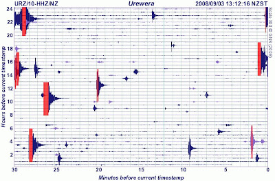
If I see a quake notification hit my inbox, and it's from the Bay of Plenty, I can pretty well guarantee it's from near Matata.
Here's a look at the latest reading from the nearest seismograph. Thanks to GeoNet.

Unnatural events
Not all emergency events are caused by Mother Nature. Sometimes we're the ones who cause the incident - just like today, where a chemical leak in Christchurch has caused the evacuation of a processing plant, and several city blocks surrounding the site. Nine people have been taken to hospital so far, after being overcome by fumes, and the police & fire service have set up decontamination showers for people leaving the area. I've seen decontamination showers in action, they aren't a lot of fun for the person being scrubbed down - though certainly better than whatever the contamination was going to do to you.
http://www.stuff.co.nz/4679493a11.html
And occassionally we do something bad to Mother Nature - there's the Sidoarjo mud eruption in Java, Indonesia, which has continued unabated for almost two years, flooding an area of 7 km2 and displacing more than 25,000 people. There is some debate as to the cause of the eruption, but scientists now blame a well drilling blowout, rather than an earlier earthquake. Oops! Bit worse than hitting the water or gas main with your digger....
http://geology.geoscienceworld.org/cgi/content/abstract/36/8/639
http://en.wikipedia.org/wiki/Sidoarjo_mud_flow
Monday, September 1, 2008
More Kawakawa Bay properties at risk from landslip
A large landslip in Kawakawa Bay, in the Manukau District, near Auckland, has caused 6 properties to be declared to be unsafe, forcing the residents to move out. The road is also closed, and could stay that way for up to a month. Because of the inconvenience to residents, the council will put on a free ferry between Kawakawa Bay and Pine Harbour marina, as well as a limited bus service to Papakura and Thames. Other contingency plans are also being put in place. Students who normally go to school in Clevedon will use a room at Orere School and be taught by their usual teacher. Work is also being done to make sure electricity and phones won’t be cut off if a landslip happens. The council is also looking at temporary alternative routes around the landslip.
http://www.manukau.govt.nz/default.aspx?id=9651
http://www.zoomin.co.nz/map/nz/manukau/kawakawa+bay/ - a map so you have some idea of where it is.
Imagine not being able to drive down the road for a month, and having to catch a ferry to get out of town. That's what it could be like for us, if a big quake took out the main roads in. Even though we're a good sized city, it's pretty easy for us to be cut off.
Missed another one!
Rather busy day today! A quake measuring 5.8 has struck 10km south-east of Turangi, near Lake Taupo. Apparently it was felt as far away as Wellington, but I didn't feel a thing! How disappointing! I went to check the seismographs on GeoNet, but they seem to be having a few problems at the moment, and haven't updated in a few days. But if you felt the earth move at 1.21pm, then please fill in a felt quake report
At least we're not on the West Coast!
Can you imagine getting half a metre of rain dumped on you in just three days? Well, that's what the MetService is saying that the Westland ranges and Southern Alps can expect this week. 500mm!
The wild weather is the result of a record-breaking, 1040HP high-pressure system, which the MetService's Bob McDavitt said is a first for New Zealand. "It's breaking all records, we've never seen a high this big over the country before. We haven't got any explanation as to why this high-pressure is so high."
Strong winds are also expected to batter the South Island, with gusts up to 140kmh predicted for inland and exposed parts of Southland, Otago, and Canterbury this afternoon, easing later tonight.
You thought our rain was bad?
Spare a thought for the poor people of South Asia, where hundreds of thousands of people are marooned in remote villages by flooding caused by the monsoon rains.
Floods have killed more than 1000 people in South Asia since the monsoon began in June, mainly in India's northern state of Uttar Pradesh, where 785 people died, and deaths were also reported in Nepal and Bangladesh. At least 3 million people have been displaced and those figures could rise as heavy rain continued, officials said.
The latest flooding occurred after the Kosi river burst a dam in neighbouring Nepal earlier this month and changed its course, swamp hundreds of villages in Bihar and destroy over 100,000 hectares of farmlands. More than 350,000 people have been evacuated over the past 11 days, officials said, admitting they did not have enough boats or resources to step up relief operations. Cases of diarrhoea were beginning to be reported from many relief camps in the state, Unicef said.
http://www.stuff.co.nz/4675899a12.html
Hurricane Gustav
The mayor of New Orleans has ordered the evacuation of the city, in the face of Hurricane Gustav, a category four hurricane, the second-highest on the five-stage Saffir-Simpson scale, labelled "the mother of all storms". The hurricane had weakened to category three over Cuba, where it killed at least 86 people, but it still looks as though it is more powerful and more destructive than Hurricane Katrina which devastated the area in August 2005.
Just one day after the third anniversary of Hurricane Katrina, many had already decided to leave their homes, with the government providing buses and trains for those who can't leave without assistance.
The city's West Bank was largely spared by Katrina, but could see "significant flooding" because its 3-metre levees are no match for Gustav's storm surge, which could top 5 metres.
Katrina's massive storm surge broke through protective levees on August 29, 2005, and flooded 80 percent of the city. It killed about 1500 people along the US Gulf Coast and caused US$80 billion in damages, making it the costliest US natural disaster.
There was bumper-to-bumper traffic on highways leading out of the city on Saturday, and six low-lying parishes - the Louisiana equivalent of US counties - issued evacuation orders.
All major Louisiana interstates will allow only one-way traffic away from the coast starting at 4am (9pm NZT) on Sunday. The last flight out of the New Orleans airport is scheduled to depart at 6pm (11am Monday NZT) on Sunday.
In all, 11.5 million people are in the path of Gustav, according to the US Census Bureau.
http://www.stuff.co.nz/4675601a12.html - New Orleans mayor orders evacuation
http://www.stuff.co.nz/4675927a12.html - Thousands flee New Orleans
http://www.stuff.co.nz/4676485a12.html - Possible scenarios for Hurricane Gustav
http://www.stuff.co.nz/4676503a12.html - Cuba tallies Gustav's economic damage
Just goes to show...
The Chinese province of Sichuan has been hit by another earthquake - measuring somewhere between 5.7 and 6.1 (reports vary), at about 7.30pm NZ time. It killed 28 people, injured 250, damaged or destroyed nearly 100,000 homes, and affected at least 600,000 residents. It was followed 24 hours later aby a 5.6 aftershock, from which there were no immediate reports of damage. Over 600 schools were damaged, and heavy rain and difficult terrain were hindering rescue efforts.
Compare this to New Zealand. Hastings was hit by a quake that measured 5.9 on the Richter Scale, just last Tuesday. It moved some furniture around, and knocked a lot of things off shelves, but really didn't cause much structural or significant damage. Even the Gisborne quake, measuring 6.8, didn't cause that much damage - all thanks to New Zealand building standards. It all goes to show that building standards make a difference. We have them for a reason, so no cutting corners!
Compare this to New Zealand. Hastings was hit by a quake that measured 5.9 on the Richter Scale, just last Tuesday. It moved some furniture around, and knocked a lot of things off shelves, but really didn't cause much structural or significant damage. Even the Gisborne quake, measuring 6.8, didn't cause that much damage - all thanks to New Zealand building standards. It all goes to show that building standards make a difference. We have them for a reason, so no cutting corners!
Friday, August 29, 2008
Lights out for South Island?
http://www.stuff.co.nz/4673682a11.html
The South Island's electricity supply is hanging by a thread this afternoon as a pylon carrying power from the North Island threatens to buckle in the Marlborough Sounds.
All the recent crap weather is certainly having an effect on things.
Have you got a way of cooking dinner if you don't have power? Gas cookers are ideal, but a barbecue will do if you have nothing more efficient. Just don't forget to check that your gas bottle is tested, and not empty!
Thursday, August 28, 2008
Kia Takatū
Today marked the launch of the Ministry of Civil Defence & Emergency Management's new school resource Kia Takatū - the Māori language version of What's the Plan, Stan?
The national launch took place at Te Kura Māori o Porirua, a Māori language immersion school in Waitangirua. My first powhiri! I was most impressed. There were speeches from kaumātua, Mayor Jenny Brash, and the Minister of Civil Defence & Emergency Management Rick Barker. I really wish I could understand more of the speeches, but that's why I'm learning Te Reo Māori.
Anyway, Kia Takatū will shortly be available to a school near you, and we'll also be getting a copy for the library.
Wednesday, August 27, 2008
Will it never end?
Our colleagues over the hill in the Wairarapa have also had a busy couple of days, with widespread flooding swamping paddocks and roads throughout the area.
The Waihenga Bridge over the Ruamahanga River on State Highway 53 at Martinborough is closed, and Pukio West Rd Kahutara and Pahautea roads are also impassable.
Heavy rain over the past 36 hours has put pressure on the town's sewerage system and a couple of families were put in motels last night as sewage threatened to contaminate their homes. Eight other homes in the Masterton area have been supplied with portable toilets until conditions improve.
And down in North Canterbury the clean-up begins - again... http://www.stuff.co.nz/4669975a11.html
Tuesday, August 26, 2008
More news
http://www.stuff.co.nz/ is just full of emergency management news today!
http://www.stuff.co.nz/4669517a11.html - Major quake likely to be confined to one island - NIWA scientists have found there are no major fault lines connecting the North and South Islands meaning the devastating effects of a major quake could be confined to just one island.
http://www.stuff.co.nz/4668712a19715.html - Kaikoura, Seddon, Blenheim and Picton are taking a pounding from a rain front that has cut roads and railway lines and caused widespread surface flooding along the east coast of the South Island. The tiny township of Peketa, south of Kaikoura, is being evacuated after flooding threatened the settlement, as the Kahutara River burst its banks
http://www.stuff.co.nz/4668674a11.html - and the cost of these storms just keeps on climbing.
Insurance is a Good Idea!
Here's some images from the last lot of flooding North Canterbury got, at the end of July.
http://www.hurunui.govt.nz/Services/EmergencyManagement/Flood08.htm
There's a rather nice pub in Amberley - great food. I do hope it survived without harm.
But wait, there's more!
If bad weather and earthquakes weren't enough, there's an oil spill along State Highway 2 in Lower Hutt causing traffic hold-ups. http://www.stuff.co.nz/4669463a11.html
I feel the earth move under my feet
Actually, I was fast asleep when an earthquake measuring 5.9 struck Hastings at 11.25pm last night, so I didn't feel a thing. The quake was centred 10km southwest of Hastings at a depth of 30km, and caused items to fall off shelves, and furniture to move around. People have felt it as far away as Feilding.
Hastings Civil Defence took the precaution of activating its emergency plan, but the area got off lightly with few reports of damage. The National Crisis Management Centre hadn't been activated, however, the response team was monitoring the situation.
Police in Hastings and Napier said they had not heard of any significant damage as a result of the quake, but there were reports of brief power outages in some suburbs.
There was an aftershock measuring 3.5 ten minutes later as well.
Stuff article - http://www.stuff.co.nz/4668752a11.html
GeoNet quake report - http://www.geonet.org.nz/earthquake/quakes/2958743g.html
Monday, August 25, 2008
Soggy Cantabrians
For once it isn't us getting stuck with the bad weather. Hopefully our colleagues down south aren't being kept too busy with the flooding and slips caused by recent rain. http://www.stuff.co.nz/4668037a11.html
Volcanoes!
Several volcanoes have erupted in the past few months - two in Chile (Chaiten and Llaima) and one in Alaska (Okmok). At any given time, approximately 20 to 50 volcanoes are active worldwide (depending on the definition of "active"). Collected here are photos of volcanic events from the the past several years, seen from many angles, including low Earth Orbit.
http://www.boston.com/bigpicture/2008/07/recent_volcanic_activity.html
New Zealand's volcanoes aren't doing much exciting at the moment, but you can always have a look at the volcano cams at GeoNet http://www.geonet.org.nz/volcano/activity/index.html
See if you can find Dino!
http://www.boston.com/bigpicture/2008/07/recent_volcanic_activity.html
New Zealand's volcanoes aren't doing much exciting at the moment, but you can always have a look at the volcano cams at GeoNet http://www.geonet.org.nz/volcano/activity/index.html
See if you can find Dino!
Wednesday, August 20, 2008
Another little quake
Looks like we had another little earthquake last night. Did any of you feel it? Don't forget to fill in a GNS felt earthquake report if you did.
The GNS report:
Universal Time: 19 August 2008 at 08:58
NZ Standard Time: Tuesday, 19 August 2008 at 8:58 pm
Latitude, Longitude: 41.02°S, 174.87°E
Location: 10 km north of Porirua
Focal depth: 5 km
Richter magnitude: 2.9
Web page: http://www.geonet.org.nz/earthquake/quakes/2955786g.html
Felt in Pukerua Bay and Porirua.
Friday, August 15, 2008
Crash! Boom! Hey, who turned out the lights?
And the wild weather continues.... http://www.stuff.co.nz/4656944a11.html
EDIT: and another article from Saturday - http://www.stuff.co.nz/4657682a7693.html
I love thunderstorms, especially forked lighting. I tend to throw open the curtains and find a comfy place to sit, so I can watch the light show. I wish I could say the same for my cat, he was terrified, and spent the night hiding under the duvet. Someone recently posted a link to some really amazing slow motion film of a lightning bolt: http://gizmodo.com/5034458/ Spectacular!
But thunderstorms can be pretty dangerous. The weather systems that produce them are very turbulent, and can produce strong winds, bursts of extremely heavy rain, and hail, just like last night and this morning. Thunderstorms can also produce tornadoes. Lightning strikes can cause all sorts of problems, especially when they hit things like power substations or power lines.
If you're outside when a thunderstorm rolls in, go inside! You can stay in your car if that's your only option, just don't touch any of the metal bits. If you can't find shelter, stay away from tall, isolated objects such as trees, poles, or posts. Make sure that you are not the tallest object by crouching down. Crouch down, bend forward, and grab your ankles. Keep your head down. Don't lie flat on the ground and try to keep out of puddles or other standing water.
Don't use a phone or a computer during a thunderstorm - it's best to turn them off and unplug them, even if you have surge protection. Don't take a shower or wash dishes. Lightning can strike the plumbing or electrical wires that connect to your house and give you an electrical shock if you use these items.
After the storm passes, wait about half an hour before leaving the house. Lightning can still be prevalent in the sky, and more storms may come.
If there are downed power lines anywhere around you, DO NOT touch them. Stay well away and call your electrical company and have them take care of it.
A power line came down in Dimock St, Titahi Bay, and chunks of Porirua lost power, and radio reception too when one of the transmitters was hit.
You all know where your torch and spare batteries are, right?
Stay safe out there.
Tuesday, August 12, 2008
2nd Australasian Natural Hazards Management Conference 2008
July 29 and 30 was spent at the 2nd Australasian Natural Hazards Management Conference. You'd think that with "Australasian" in the title it would be held somewhere warmer, where people wear thongs, not jandals, and sound like the cast of Neighbours. But not this time. This year's conference was held in Wellington, so instead of catching a flight to sunny Australia, I caught the train into town and walked to Te Papa in the rain.
There were some quite interesting subjects presented by people from Australia, the US, and other parts of the world. There were a few which stood out for me.
Planning how to rebuild after a major distaster - building back better - not necessarily replacing things as they were - some things were essentially poorly placed to begin with - taking some social responsibility as to what replaces things. Hurricane Katrina examples of areas of significant cultural heritage being replaced with casinos on the beach front - not good. Hopefully we can do better.
Legal issues around natural hazard information - This one was quite relevant for us - especially with regard to the new tsunami information that is becoming available. Once we know that a property is in a potential hazard area we have a responsibility to let the owners know - even if that means that property values drop. The thing is, the hazard risk has pretty much always been there, we're just letting people know of the risks that they may face, so that they can be better prepared. We'd get into more trouble if we didn't tell you.
Community resilience through co-operation - Disasters often span district boundaries. We were given examples from Australia of how municipal authorities were finally joining together to deal with events in a cooperative way, sharing resources, rather than duplicating efforts. Fortunately, in New Zealand, we've been doing this for quite some time, and even have it built into our legislation. It's nice to be ahead of the curve for a change! Go us.
The Mayor of Gisborne gave us a run down on on the quake in December 2007.
There was also a presentation on the Northland floods of 2007, which could very well have been retitled the Northland floods of 2008, and run in real time. The weather was quite attrocious that day. The Metservice had their rain radars on display constantly in the display area, so we had a constant update on how the storm was progressing whenever we had a break. Some of the EMOs were having to rejig flights so they could get back to their districts to deal with it all.
A well-spent two days.
Friday, August 8, 2008
I leave you alone for a few days, and look what happens!
That's just typical... I go on holiday and Porirua gets hit by flooding and slips, and actually activates the incident room. I missed all the excitement!
The 31st of July was a pretty bad day weatherwise for much of the country. Porirua was the unlucky recipient of a very intense, and very localised band of heavy rain that coincided with the peak high tide. This managed to create a little mayhem from Titahi Bay, Mana, across to Papakowhai and Paremata with flooding (waist deep in places!), slips, and overflowing and backed-up sewerage pipes. Ew...
Our call centre had to bring in extra staff from other departments in order to deal with the influx of calls in such a short time - they estimate that we got about 250 calls. Our operations team were very busy, but coped admirably with all the call-outs, even the stinky ones.
What you can do if your property has been flooded (possible sewage contamination)
courtesy of Jim Sutton, Manager Environmental Standards
The main concerns with any sewage-contaminated surface water is that it can carry micro-organisms which can cause sickness. Therefore, where possible, people should avoid areas where contamination has occurred. So don't let children play in surface water. People should ensure that they wash their hands thoroughly before preparing, or eating food. If you have to walk through contaminated areas, take off footwear before going inside. Items that have been contaminated need to be washed thoroughly in clean water and disinfectant.
Once things start to dry off, contaminated driveways and other hard surfaces can be hosed clean. Contaminated items can also be wiped down with a disinfectant. Lawns and under-basement areas can have burnt lime (quick lime, Calcium Oxide ) applied - this acts as effective disinfectant. Care should be taken when applying burnt lime as it is caustic to the eyes and skin.
Friday, July 25, 2008
But wait, there's more!
I'm not entirely sure when we last had a weekend with nice weather, but here comes another storm. It's going to cause lots of rain, and possibly flooding through much of the North Island, but Wellington is going to get more wind. Southeasterly winds gusting to 110km/h in exposed places until Sunday.
More on the incoming storm can be found on Stuff - http://www.stuff.co.nz/4629994a11.html
More on the incoming storm can be found on Stuff - http://www.stuff.co.nz/4629994a11.html
Thursday, July 24, 2008
We're not the only ones with bad weather
Hurricane Dolly, the second of the 2008 Atlantic hurricane season, has hit the south Texas coast, with 150km/h winds and torrential rain, causing flooding and plenty of damage.
http://www.stuff.co.nz/4628923a12.html
http://www.stuff.co.nz/4628923a12.html
Earthquake in Japan
A strong earthquake (~6.8 - the same size as the Gisborne quake in December) has shaken northern Japan, injuring almost 100 people, trapping hundreds in trains, and cutting power to over 6,000 homes. The Japan Meteorological Agency said there was no threat of a tsunami from the quake, which struck at 12:26am local time (3:26am NZT) and could be felt as far away as Tokyo. Today's quake follows a string of earthquakes in the same region, the first of which in mid-June killed at least 10 people.
EDIT: 3:50pm
There's been an aftershock there, at 2.27pm our time - measuring 5.0 on the Richter scale.
EDIT: 3:50pm
There's been an aftershock there, at 2.27pm our time - measuring 5.0 on the Richter scale.
And the wild weather continues
Yesterday's exciting weather caused problems all over the region - huge swells, heavy rains, closed roads, derailed trains, flooding, slips, huge traffic delays. People in Levin now have to boil their water as their treatment plant was affected by flooding. Stuff has an article on it here - http://www.stuff.co.nz/4628621a10.html.
And now we can expect strong southerly gales with 70km/h winds gusting to 120km/h in exposed places until about 11pm tonight. Winds that strong can damage trees, powerlines, and insecure roofs, as well as push large vehicles around on roads - so be careful out there!
EDIT: 4:50pm
Ferry sailings and some flights out of Wellington have been cancelled due to the strong winds and high seas.
Wednesday, July 23, 2008
What are you going to do if you can't get home?
The weather is pretty nasty today, and stormy seas are washing waves and debris onto the road, making travel along State Highway 1 between Pukerua Bay and Paekakariki quite dangerous. Police are recommending that motorists stay away from that section of Centennial Highway for a few hours until well after high tide. Stuff has an article on it here - http://www.stuff.co.nz/4628364a19715.html
EDIT: 4:45pm And now they've closed SH1.
http://www.stuff.co.nz/4628364a10.html
Many people who work in Porirua live up the coast. It'd be pretty darn annoying if you were planning on driving through there any time around now, but just think what it would be like if things were so bad that the road was washed out, or a slip fell and blocked both lanes! What would you do if you can't get home tonight?
Have you got somewhere you could stay? With friends or family, or on an office couch at work?
Is there someone to look after your kids? Is there a friend or neighbour, or other family member who can keep them fed and looked after until you get home? Make sure that you've informed the school if someone other than you is allowed to pick up the kids from school.
Take a few minutes to think about these things, and give your neighbour/friend a call to see if that's something they can do for you, if you ever can't get home. And don't forget to let your family know what the plan is too!
Tuesday, July 22, 2008
New six-part civil defence radio series
When the Siren Goes is a new six-part radio series from Radio New Zealand National which explores our level of disaster awareness and considers the public response that would follow a major civil defence emergency.
The series features unique archival audio from Radio New Zealand Sound Archives, including remarkable recollections from a witness to the Mount Tarawera eruption of 1886, recorded 70 years after the event.
In addition to the radio broadcasts, all audio will be available on demand and as podcasts from a special section of the Radio New Zealand website. The web section will be live from the date of the first broadcast on Friday July 11, 3:30pm and features additional archival audio, visual information including photos and video clips, and a range of links to local and international web resources.
When the Siren Goes is a series of programmes produced and broadcast as a public value partnership between Radio New Zealand and the Ministry of Civil Defence & Emergency Management. Radio New Zealand is a designated lifeline utility organisation responsible for the broadcast of emergency warnings and public information in the event of a civil defence emergency.
NOTE: Apart from the sirens on the volunteer fire stations at Titahi Bay and Plimmerton, Porirua does not currently have any kind of civil defence warning sirens.
Monday, July 21, 2008
Discredited earthquake safety advice circulated in NZ
A media release from the Ministry of Civil Defence & Emergency Management from 5 June 2008 - I figured it was worth reposting here, since that email is still doing the rounds.
New Zealand agencies involved in promoting earthquake safety are concerned that advice from a source discredited overseas is being circulated by e-mail in New Zealand.
The Ministry of Civil Defence & Emergency Management, the New Zealand Society for Earthquake Engineering, the Earthquake Commission (EQC) and GNS Science have spoken out against the e-mail, sometimes known as the “triangle of life”. They have done so because the e-mail discourages people from taking what is usually the safest option, covering under desks, in doorways etc.
“When an earthquake starts, the best advice is still to ‘drop, cover and hold’,” the Ministry’s Director, John Hamilton said.
A link to the earthquake fact sheet (pdf) on the Ministry’s website, http://www.civildefence.govt.nz/, can be found here. The fact sheet is the agreed New Zealand advice about what to do during an earthquake. It is based on international best practice.
We have had queries from Members of Parliament, schools, Citizens’ Advice Bureaus, media and members of the public about the misleading advice, which includes the dangerous statement that “people who get under objects, like desks or cars, are crushed”.
Mr Hamilton said that the drill practised by schoolchildren will protect people in most earthquakes. That drill is to drop, take cover under a sturdy piece of furniture, and hold on, or shelter against an interior wall away from windows, bookcases etc.
“In a severe earthquake it is absolutely vital that people respond immediately. Confusion about what to do can result in people getting seriously injured or killed,” Mr Hamilton said.
“Our advice is to identify safe places in your home, office or school before an earthquake so that when the shaking starts you can respond quickly.
An immediate response to move to the safe place can save lives. And that safe place should be within a few steps – no more than two metres – to avoid injury from flying debris.”
Just because you think someone should have done it, doesn't mean that they have
Something that's been popping up lately (I've done it twice in the past fortnight) - making 111 calls. A lot of the time, people will assume that someone has put a call through to Fire, Ambulance or Police, especially if the incident is somewhere lots of people can see it. The problems is, everyone is thinking exactly the same thing - Oh, someone will have done it already, I don't need to. And nobody makes the call!
And just because you'll see people holding cellphones, furiously pushing buttons, don't presume that means someone is making the call either. More often than not, they're texting their friends about it, or taking a picture with the built-in camera, and then texting it to all their friends.
So, for the sake of the safety of anyone who may be involved - time is often very critical - if you see something that needs to be dealt with by emergency services, pick up the phone, and dial 111. It's free (even if your phone is out of credit), and the worse thing that can happen is that you'll be told they've already received the call, thank you for calling. The consequences of not having help arrive as soon as possible could be fatal.
Things to remember when dialling 111:
The operator will ask whether you want Fire, Police or Ambulance - don't give them the story, tell them which service you need. If you aren't sure which you need, ask for the Police, and tell them what is going on, and they can organise everything else required.
For vehicle accidents where people may be injured, you'll want both the Ambulance and the Police, and maybe Fire too. The operator will put you through to the ambulance service first, and listen in to get the details to pass on to the Police and Fire.
Remain calm, and speak clearly.
Identify where the incident is. They can't help you if they can't find you! Building names, street numbers, street names, town or city - the call centre often isn't actually in your city, so they won't know which Main Road you are talking about unless you tell them! Identify the nearest intersections if you can. If you are in a rural area, things like the RAPID rural number of the nearest address, and any landmarks can be useful.
Don't forget to give them you phone number so they can call you back if they need more information. Caller ID doesn't work well if you are calling from an office phone on a PABX system for example, and some phone numbers just don't show up.
You're going to be asked a lot of questions about what is going on, but every bit of information is useful.
Stay on the phone until they tell you that you can hang up. You can also ring 111 again if things get worse, or the services haven't shown up when you expect them to.
More information on the 111 service can be found here - http://www.111.govt.nz/calling_111/when_111.html
I know things are tough, but please don't...
There was recently an article on Stuff (http://www.stuff.co.nz/4580604a7773.html) that really made me cringe. "Simple hints to lower your food bill" by Jackie Gower - Waikato Times - Thursday, 12 June 2008.
It's essentially recommending that you completely empty your cupboards before replenishing your stocks with a trip to the supermarket, using up the food you already have before going shopping for more. It may save money in the short term, but it's not a good survival instinct!
In the event of a large-scale emergency, food is going to be in very short supply. Your average supermarket has gone to the "just-in-time" supply model. Sure, it means that everything is nice and fresh, but it also means that your supermarket will empty in just a couple of days, if it doesn't have an almost-constant stream of trucks resupplying it. And during an emergency, those trucks aren't going to be making deliveries for quite some time. You're going to have to live off of what is in your cupboards, and unfortunately, we can't guarantee that disaster day is going to happen just after shopping day.
Ideally, you should be able to feed yourself and your household for at least 14 days, from just the food in your house. This doesn't mean that you have to have a special stash of food squirrelled away under the house for the Apocalypse - unless you are very organised, that's pretty well a recipe for having a stash of expired food that isn't much good to anyone. Keep it in the pantry, where you're going to see it and eat it, and replace it.
If you don't like lentils, then there's no point having a bag languishing in the cupboard. Store food that you normally eat. Things that you usually serve up for dinner or lunch. That way the food gets used and replaced, and you don't have to worry about having a slightly rusty tin of something unidentifiable lurking in the back of the cupboard, just waiting to give someone botulism, and quite possbly tetanus when they try getting in to it. If you find you have things that you know you aren't going to eat, throw them out if they have gone past their expriy date, or put them in the donation bin at your local supermarket if they are still good.
14 days of food sounds like a lot, and it certainly is if you have to buy it all in one go! But you don't have to buy it in one go. You've already got a surprising amount of stuff in your cupboards - that's one of the points of the original article. It built up over a time. A spare tin of baked beans here, you forgot you already had a packet of pasta in the cupboard, so bought another one. No one can remember who bought the lentils. All you have to do now is deliberately extend that buffer a bit, and turn it into something useful.
The orginal article does have a good idea - only buy what you need. The amount of time I spend in the supermarket, and the amount of money I spend has been drastically reduced by simply having a list. My trick is that I have a spreadsheet which I made up, printed off, and photocopied a few times. It has all the stuff I would expect to be able to find in my cupboards and fridge. Before I go do the shopping for the week, I go through the list and cross off anything that I've already got, leaving the things that I don't have, so need to pick up. Some things get crossed off the list 50 weeks of the year - I don't buy lightbulbs very often, but that's okay, the fact that I cross it off the list means that I have two in the cupboard.
A good list of things to have in the pantry can be found here.
So, DON'T empty your cupboards before going shopping, just buy what you need to keep your cupboards full. You never know when the next emergency is going to happen, and it's not going to postpone itself until you've done the shopping!
Shakin'
Ah, Wellington... Earthquake-free for four days less than one day.
There was one on Wednesday afternoon (4.1), and then another on Sunday morning (3.4), and I didn't feel any of them!
If you happen to feel an earthquake, or think you felt one, check out the seismograph readings of the quake drum for South Karori. It's the local one for our area. Little quakes show up quite frequently, as can be seen by this snapshot (click on it to enlarge). The lower blip is from a 4.1 quake centred near Wanganui at 7.29am this morning, and the other one from something more local (3.5, 10km east of Picton) at 2.23am. These little things barely rate a mention, except that they happen a lot. You can't say that we don't have earthquakes!

Quake information courtesy of http://www.geonet.org.nz/
Here's the statistics for the two recent earthquakes.
NZ Standard Time: Sunday, 20 July 2008 at 8:41 am
Latitude, Longitude: 41.39°S, 174.97°E
Location: 20 km south-east of Wellington
Focal depth: 30 km
Richter magnitude: 3.4
Web page: http://www.geonet.org.nz/earthquake/quakes/2938906g.html
Felt across the Wellington region
NZ Standard Time: Wednesday, 16 July 2008 at 1:42 pm
Latitude, Longitude: 40.94°S, 174.65°E
Location: 30 km north-west of Porirua
Focal depth: 70 km
Richter magnitude: 4.1
Web page: http://www.geonet.org.nz/earthquake/quakes/2938906g.html
Potentially felt in the lower North Island and the Marlborough region.
Hello!
I'm an Emergency Management Officer with Porirua City Council, and I decided that we should have a blog about emergency management stuff, so here we are temporarily.
It'll be a pretty random collection of thoughts, rants, tips, links and anything else that I happen to think of as being relevant to my field.
It's all my personal opinion, so don't go trying to infer any council policy from it. If in doubt, contact the city council. http://www.pcc.govt.nz/
There are a lot of posts for today, but that's because I had a few cued up elsewhere, just waiting to be published. It may not be updated everyday, or even every week - I've got work to do!
Subscribe to:
Comments (Atom)

